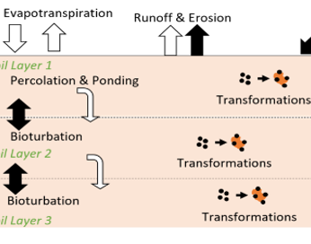
Soil Erosion in the NanoFASE Model
In order to quantify soil erosion in the model it is necessary to calculate the sediment yield (Sy). To do this, the MUSLE equation (equation 1) is a modification of the original USLE which included soil erodibility (K), cover and management (C), practice (P) topography (LS) and a coarse fragment factor (F).
| \(S_{y}=(q_{surfQ_{peak}A})^{0.56}.K_{USLE}.C_{USLE}.P_{USLE}.LS_{USLE}.F_{USLE}\) [Equation 1] |
The modification involved representing the USLE rainfall erosivity factor (R) with surrogate information from runoff (qsurfQpeak and A). Qsurf is the surface runoff (mm day-1), Qpeak is the peak runoff discharge and A is the area for sediment yield calculation.
Alternatively, the rainfall erosivity term in RUSLE is defined in MJ mm ha-1 hr-1. It represents the product of rainfall kinetic energy and the maximum rainfall in a 30 minute period (KE x I30). As highly dependent on detailed records I30 is not well defined but is widely used in model applications.
However, Davison et al. (2005) propose a power law relationship (KE = aPb) to define KE on a daily resolution from daily rainfall totals (Equation 2). Across the UK no significant geographic variation was found for this relationship (Davison et al. (2005).
| \(KE_{DT}={a_{1}+a_{2}}\cos[D_{J}(\frac{2\pi }{365}+a_{3})]P^{b}\) [Equation 2] |
where: KEDT is daily kinetic energy of rainfall as direct throughfall (J m-2), P is daily rainfall (mm) and DJ is Julian Day; parameter values for UK: α1 = 6.608, α2 = 0.519, α3 = 2.727, b =1.204.
Total kinetic energy is the sum of the leaf drainage and direct throughfall components. Kinetic energy of leaf drainage is related to plant height (PH in m: leaf drainage from plants lower than 0.15 m contribute no kinetic energy) (Equation 3). The relative size of the components is defined by crop cover fraction (CC holding a value between 0 and 1) (Equation 4).
| \(KE_{LD} = 15.8.PH^{0.5}-5.87\) [Equation 3] |
\(KE = (1-CC).KE_{DT}+CC.KE_{LD}\) [Equation 4] |
As the variation of rainfall erosivity across Europe (Panagos et al., 2015) strongly reflects hydro-climatic classification it was decided to estimate R based on the rainfall kinetic energy calculation (Equation 2) for which the fitting parameters (α,b) are related to the Koppen climatic classification.
Therefore the equation adopted here (Equation 5) is a modification of RUSLE.
| \(S_{y}=KE.K_{MMF}.C_{USLE}. P_{USLE}.LS_{USLE}.F_{CFRG}\) [Equation 5] |
The soil erodibility parameter (K) adopted differs from those originally used in the USLE family of models (based on textural composition and organic matter content) by using the simpler formulation related to textural composition as used by Morgan and Duzant (2008). Units of Kmmf are g j-1 whose value is determined by the particle size fractions (Fclay, Fsilt and Fsand which hold values between 0 and 1) and coefficients related to those fractions (Equation 6).
| \(K_{MMF}=F_{clay}.0.1+F_{silt}.0.5+F_{sand}.0.3 \) [Equation 6] |
The cover and management factor CUSLE is defined as the ratio of soil loss from land cropped under specified conditions to the corresponding loss from clean-tilled, continuous fallow. Though data exists for temporally-averaged CUSLE factors in Europe (Panagos, Borrelli, Meusburger, Alewell, et al., 2015), these do not take into account daily variation in plant cover, and daily CUSLE factors are calculated empirically (Neitsch et al., 2011):
\(C_{USLE}=exp((ln(0.8) -ln(C_{min}))exp(-0.00115\cdot r_{surf})+ln(C_{min}))\) [Equation 7] |
where rsurf is the crop residue on the soil surface [kg/ha] and Cmin is a minimum CUSLE calculated as follows:
\(C_{min}=1.463\cdot ln(C_{av})+0.1034\) [Equation 8] |
where Cav is the average annual CUSLE factor.
The support practice factor PUSLE is defined as the ratio of soil loss with a specific support practice (e.g. contour ploughing) to the corresponding soil loss with up-and-down slope culture. Spatially-resolved data to 1-km resolution are available for Europe (Panagos, Borrelli, Meusburger, van der Zanden, et al., 2015).
The topographic factor LSUSLE takes into account the steepness and slope of the hillslope on which erosion is occurring. It can be calculated from hillslope length and slope angle (Neitsch et al., 2011) and spatially-resolved data are available at 25- and 100-m resolution (Panagos, Borrelli, & Meusburger, 2015).
The coarse fragment factor FCFRG takes into account the amount of rock in the soil profile, and is calculated as:
| \(F_{CFRG} = exp(-0.053\cdot rock)\) [Equation 9] |
where rock is the percentage of rock in the first soil layer. Thus, FCFRG =1 when no rock is present.
|
|
Used in |
|
|

Read more |
Read also |
|
Consult the NanoFASE Library to see abstracts of these deliverable reports: |
Davison PS, Withers PJA, Lord EI, Betson MJ, Strömqvist J. PSYCHIC – A process-based model of phosphorus and sediment mobilisation and delivery within agricultural catchments. Part 1: Model description and parameterisation. Journal of Hydrology. 2008 Feb; 350(3-4):290–302. Morgan R, Duzant J. Modified MMF (Morgan-Morgan-Finney) model for evaluating effects of crops and vegetation cover on soil erosion. Earth Surface Processes and Landforms. 2008; 32:90–106. Neitsch S, Arnold J, Kiniry J and Williams J. Soil and Water Assessment Tool – theoretical documentation. Texas Water Resources Institute Technical Report 406 Texas A&M University System, College Station Texas US. 2011. Panagos P, Ballabio C, Borrelli P, Meusburger K, Klik A, Rousseva S, et al. Rainfall erosivity in Europe. Science of the Total Environment. 2015 Apr 1; 511:801–814. Panagos, P., Borrelli, P., Meusburger, K., Alewell, C., Lugato, E., & Montanarella, L. (2015). Estimating the soil erosion cover-management factor at the European scale. Land Use Policy, 48 (Supplement C), 38-50. doi: 10.1016/j.landusepol.2015.05.021 Panagos, P., Borrelli, P., Meusburger, K., van der Zanden, E. H., Poesen, J., & Alewell, C. (2015). Modelling the effect of support practices (P-factor) on the reduction of soil erosion by water at European scale. Environmental Science & Policy, 51 (Supplement C), 23-34. doi: 10.1016/j.envsci.2015.03.012 Panagos, P., Borrelli, P., & Meusburger, K. (2015). A New European Slope Length and Steepness Factor (LS-Factor) for Modeling Soil Erosion by Water. Geosciences, 5(2), 117-126. doi: 10.3390/geosciences5020117 Мodelling: Science of the Total Environment, v. 650, p. 530-540. |
Contact
 Mike Hutchins
Centre for Ecology and Hydrology (CEH)